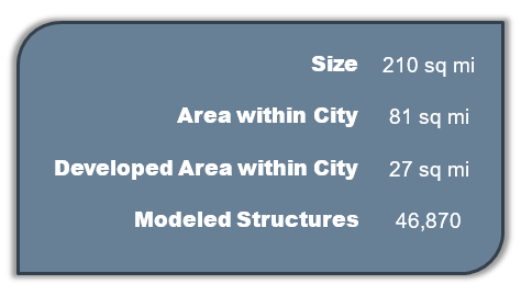


The Greens Bayou watershed is located in the northern portion of the City of Houston. Over 60% of the watershed is located outside of City limits, instead falling within unincorporated Harris County. The Greens Bayou watershed is bounded by Spring Creek to the north and Hunting Bayou to the south. The terrain in the watershed is generally flat, with Greens Bayou draining southeast into the Houston Ship Channel. The watershed within City limits is mainly developed and consists primarily of small-lot, single-family residences. Areas of undeveloped land exist in the east and southern portions of the watershed, mainly consisting of pasture and forested areas. While part of the watershed, the George Bush Intercontinental Airport (IAH) was evaluated as a separate component of the study and is not included in this summary.
 |
 |
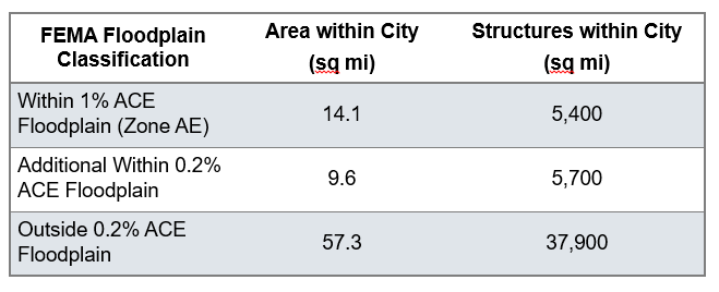
Modeling results indicate that Greens and Hall Bayous start overtopping and causing structural flooding throughout the watershed in the 10-year event. These impacts increase with the larger events as the bayou floodplain extends along with floodplains from local channels.
Beyond the flood risk associated with Greens Bayou, localized flooding can be seen in several neighborhoods and industrial areas throughout the watershed. The Northshore and Hunterwood super neighborhoods show structural flooding starting in the 2-year event. Willowbrook, Greater Greenspoint, and Northside/Northline neighborhoods show impacts to structures starting in the 5-year event. Many other areas throughout the watershed start seeing structural impacts in the 10-year and larger events due to the impacts of Greens and Hall Bayou floodplains.

